I have just been given the opportunity to go and have a good mooch around the 'Magnificent Maps' exhibition here at the British Library. On entering the crowd seems pretty typical, the over 60's and the trendy young mums who've pushed their designer prams to something fabulously intellectual in hope that baby will absorb it, but the further in I get I can see more and more young people, and realise more and more as to why. These Maps are utterly beautiful.
The maps date from around the 1200's to 2008, however from my gathering I feel that the majority lie between the 1400's and 1600's. The Medieval maps put the word intricacy to shame and so I had no shame in standing with my nose only centimeters from the protective glass to try and get a better look at the tiny trees, and the tiny huts, and the even tinier men on horseback.
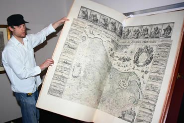
You also notice the amount of information that they have written on each of these maps, the typeface being a work of art in itself, along with the huge range of materials on which these maps are presented on, from parchment to tapestry. The range of the whole exhibition is enormous (not only in sheer volume of the number of maps there are to look at) showcaseing everything from pocket globes to the world's largest atlas and so on these grounds I seriously prompt you to go and have a look, it is free after all.
Stephen Walter's "The Island" presents London as an island, and comments on each tiny aspect with some lovely humour. There was a little crowd forming around this piece of work, each person trying to find what it says about where they live. As for my neck of the woods I was informed that it is "ye olde good place to buy your milk" - which is rather helpful actually.
Magnificent Maps, British Library, 30 April-19 September 2010.


No comments:
Post a Comment